last updated 2025 June 17
Overview
This page features some of the current research projects conducted by iHARP personnel. Each project is led by a Research Assistant under the mentorship and guidance of a iHARP Senior Researcher. Under each project title, you will find its objective, representative architecture, key publications, and a full scientific abstract.
Research projects are supported by NSF HDR iHARP Grant 2118285.
Research Focus Areas: Data Data & Model Prediction Scalability
Physics-guided Multi-contextual Learning
Key Personnel Chhaya Kulkarni, Nicole-Jeanne Schlegel, Vandana P. Janeja
Data
Research Objective
The objective of the study is to establish a multi-contextual framework based on physics principles that distinguishes between surface processes – i.e., surface melting and snowfall—and subsurface processes – i.e., ice dynamics that drive mass changes in the Greenland ice sheet.
- Physics-Guided Multi-Contextual Learning: Understanding the Surface and Subsurface Processes in South East Greenland, Chhaya Kulkarni, Nicole Schlegel, Vandana P. Janeja, Under Review, ACMSIGSPATIAL 2025.
- Machine Learning-based Variance Analysis of Brightness Temperature in Simulated Satellite Footprints, Chhaya Kulkarni, Nikki Privé, Vandana P. Janeja, I-GUIDE Forum 2025.
- Kulkarni, Chhaya, Nikki Privé, and Vandana P. Janeja. “Interactive Assessment of Variances of High-Resolution Model Features in Digital Twin Simulations.” Proceedings of the 32nd ACM International Conference on Advances in Geographic Information Systems. 2024.
- Kulkarni, C., Tama, B. A., Schlegel, N. J., & Janeja, V. P. (2024). Anomaly Detection Using Graph Deviation Networks Within Spatiotemporal Neighborhoods: A Case Study in Greenland. IEEE Journal of Selected Topics in Applied Earth Observations and Remote Sensing.
- C. Kulkarni, V. Janeja and N.. Schlegel, “Multi-Contextual Learning : Analyzing Melt Over the Greenland Ice Sheet,” IGARSS 2023 – 2023 IEEE International Geoscience and Remote Sensing Symposium, Pasadena, CA, USA, 2023, pp. 6736-6739, doi: 10.1109/IGARSS52108.2023.10281954.
This work presents a multi-contextual learning framework within spatiotemporal neighborhoods to tackle analytical challenges in Earth observation data. The rapid rise in the amount of environmental data —as demonstrated by the European Space Agency’s Copernicus program expanding from 2 to 20 petabytes per year and NASA’s Earth Observing System producing 16 terabytes per day—poses difficulties to conventional analytical methods for managing multi-source data fusion, cross-scale pattern recognition, and spatial autocorrelation.
The work develops a context-aware spatiotemporal data analysis approach with a neighborhood-based spatiotemporal framework at its foundation. The framework employs Voronoi tessellation for micro-neighborhood generation and attribute-based grouping for macro-neighborhood generation. By incorporating contextual information from spatial proximity and attribute similarity, the approach captures nuanced patterns that traditional methods tend to ignore.
This multi-contextual learning framework is validated through two complementary application domains that serve as case studies. The Greenland Ice Sheet case demonstrates how the application of neighborhood analysis successfully encapsulates intricate melt behavior, accounting for local variability and interactions between temperature, albedo, and other variables. Digital twin simulations form a second test case by demonstrating that the same neighborhood-based approach is capable of delineating areas with analogous variance structures within high-resolution atmospheric data.
The methodological contributions of the dissertation are: (1) multi-contextual learning for spatiotemporal neighborhood formation; (2) Graph Deviation Networks for multivariate anomaly detection in such neighborhoods; (3) a comparative framework for the validity verification of data sources; and (4) spatial clustering for variance analysis. Each component tackles intrinsic challenges in spatiotemporal data analysis while offering practical solutions for environmental monitoring application scenarios. Results indicate that multi-contextual learning in spatiotemporal neighborhoods substantially enhances detection and interpretation capability for complex Earth observation data, with immediate implications for environmental monitoring, modeling, and satellite-based observational systems.ralize for multiple downstream tasks and can be extended to other domains beyond Earth Science.
Modeling Heterogeneity across Varying Spatial Extents: Discovering Linkages between Sea Ice Retreat and Ice Shelf Melt in the Antarctic
Key Personnel Maloy Kumar Devnath, Sudip Chakraborty, Vandana P. Janeja
Data & Model
Research Objective
The objective of the study is to develop a graph-based framework, Spatial-Link, to detect spatial linkages between varying spatial extents.
- Devnath MK, Chakraborty S, Janeja VP. CMAD: Advancing Understanding of Geospatial Clusters of Anomalous Melt Events in Sea Ice Extent. In Proceedings of the 32nd ACM International Conference on Advances in Geographic Information Systems 2024 Oct 29 (pp. 282-292).
- Devnath MK, Chakraborty S, Janeja VP. Deep Learning for Antarctic Sea Ice Anomaly Detection and Prediction: A Two-Module Framework. In Proceedings of the 1st ACM SIGSPATIAL International Workshop on Geospatial Anomaly Detection 2024 Oct 29 (pp. 90-93).
- Devnath MK, Chakraborty S, Janeja VP. Modeling heterogeneity across varying spatial extents: discovering linkages between sea ice retreat and ice shelve melt in the Antarctic. In Proceedings of the 33rd ACM SIGSPATIAL International Conference on Advances in Geographic Information Systems (SIGSPATIAL 2025). (Under Review).
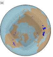
The dynamics of the Antarctic region which holds 90% of the Earth’s ice volume, particularly the interplay between sea ice retreat and land ice or ice sheets melting, demand rigorous scientific examination due to the alarming changes observed in recent decades. Antarctica’s ice mass has been diminishing rapidly, with an estimated average loss of approximately ∼ 146 billion tons annually since 2002. The reduction in sea ice extent raises critical questions about its repercussions on ice sheet melting, as sea ice provides a protective barrier separating ice sheets from warm ocean currents and wave action. While Antarctic sea ice was expanding until 2015, recent trends show a dramatic reversal with record low extents in February 2023. Understanding the relationship between sea ice changes and ice sheet dynamics is pivotal for deciphering the broader implications of global sea-level rise, a pressing concern for coastal communities, ecosystems, and policymakers. To address this, this thesis employs machine learning algorithms and remote sensing techniques to analyze temporal and spatial variations in the polar climate system. This research aims to develop innovative machine learning algorithms to detect anomalous melt events, variations in melt onset and duration, and quantify the feature similarity and associations between sea ice retreat and land ice or ice sheet melting, particularly in regions experiencing anomalous melts with earlier retreat and late accumulation periods. This thesis specifically aims to:
- Understand how anomalous melt events and variations in melt onset and melting period length impact the dynamics of sea ice retreat.
- Assess the significance of anomalous melt events compared to steady-state conditions in influencing sea ice retreat.
- Quantify feature similarity and associations (co-occurrence) between sea ice retreat and land ice or ice sheet melting in regions experiencing anomalous melts, with particular attention to earlier retreat and late accumulation periods.
By addressing these questions, this thesis contributes to a comprehensive understanding of the intricate interactions between sea ice retreat and ice sheet melting in the Antarctic region and their broader implications for global sea-level rise.
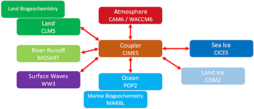
Improved Understanding of Multicentury Greenland Ice Sheet Response to Strong Warming in the Coupled CESM2‐CISM2 With Regional Grid Refinement
Key Personnel Ziqi Yin, Adam R. Herrington, Rajashree Tri Datta, Jan T. M. Lenaerts, and Andrew Gettelman
Research Objective
The objective of the study is to first, investigate the multicentury sensitivity of GrIS evolution to a changing climate, and second, compare the variable‐resolution run with global 1° resolution runs, to assess the added value of regional refinement.
- Yin, Z., Herrington, A. R., Datta, R. T., Subramanian, A. C., Lenaerts, J. T. M., & Gettelman, A. (2025). Improved understanding of multicentury Greenland Ice Sheet response to strong warming in the coupled CESM2-CISM2 with regional grid refinement. Journal of Advances in Modeling Earth Systems, 17, e2024MS004310. https://doi.org/10.1029/2024MS004310
The simulation of ice sheet-climate interactions, such as surface mass balance fluxes, is sensitive to model grid resolution. Here we simulate the multi-century evolution of the Greenland Ice Sheet (GrIS) and its interaction with the climate using the Community Earth System Model version 2.2 (CESM2.2) including an interactive GrIS component (the Community Ice Sheet Model v2.1 [CISM2.1]) under an idealized warming scenario (atmospheric increases by 1%/yr until quadrupling the pre-industrial level and then is held fixed). A variable-resolution (VR) grid with 1/4° regional refinement over the broader Arctic and 1° resolution elsewhere is applied to the atmosphere and land components, and the results are compared with conventional 1° lat-lon grid simulations to investigate the impact of grid refinement. Compared with the runs, the VR run features a slower rate of surface melt, especially over the western and northern GrIS, where the ice surface slopes gently toward the periphery. This difference pattern originates primarily from higher snow albedo and, thus, weaker albedo feedback in the VR run. The VR grid better captures the CISM ice sheet topography by reducing elevation discrepancies between CAM and CISM and is, therefore, less reliant on the downscaling algorithm, which is known to underestimate albedo gradients. The sea level rise contribution from the GrIS in the VR run is 53 mm by year 150 and 831 mm by year 350, approximately 40% and 20% less than that of the runs, respectively.
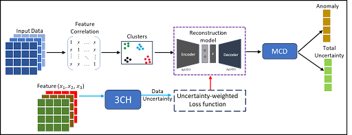
Uncertainty-Aware Anomaly Detection in Spatiotemporal Climate Data
Key Personnel Tolulope Ale, Ratnaksha Lele, Nicole-Jeanne Schlegel, Vandana P. Janeja
Research Objective
The objective of the study is to develop a framework to quantify data uncertainty and propagate this uncertainty through the learning network, thus balancing the weights assigned to certain and uncertain inputs. Overall, the framework outputs a total uncertainty for each input and provides a basis to quantify the confidence level of predicted anomalies. This framework was used to analyze anomalous melt events of ERA5, MAR, and GEMB products.
- T. Ale, V. P. Janeja and N. -J. Schlegel, “Harnessing Feature Clustering For Enhanced Anomaly Detection With Variational Autoencoder And Dynamic Threshold,” IGARSS 2024 – 2024 IEEE International Geoscience and Remote Sensing Symposium, Athens, Greece, 2024, pp. 8692-8696, doi: 10.1109/IGARSS53475.2024.10640794.
- Ale, T., Schlegel, N. J., & Janeja, V. P. (2025). Advancing climate model interpretability: Feature attribution for Arctic melt anomalies. arXiv preprint arXiv:2502.07741. Under review @ 25th IEEE International Conference on Data Mining (IEEE ICDM 2025), November 12-15, 2025, Washington DC, USA
- Ale, T., Ratnaksha, L., Schlegel, N. J., & Janeja, V. P. (2025). Uncertainty-Aware Anomaly Detection in Spatiotemporal Climate Data. Under review @ 33rd ACM SIGSPATIAL Int. Conf. on Advances in Geographic Information Systems (ACM SIGSPATIAL 2025. Nov. 3 – Nov. 6, 2025. Minneapolis, MN, USA
- Ale, T., Bayu, T., & Janeja, V. P. (2025). Adversarial Multitask Learning for Accurate Change Detection in Multi-Temporal Satellite Images. Under review @ ACM Transactions on Spatial Algorithms and Systems
The multivariate time series analysis within climate data represents a crucial yet less explored field. This is particularly relevant when examining extreme climate events, such as snow melting in polar regions, which necessitate the consideration of multiple variables to capture fluctuations accurately. Anomalies in climate data often result from the interplay of several variables, meaning that what appears anomalous under univariate analysis may, in fact, align with expected patterns once contextualized within a multivariate framework. This approach more accurately reflects the interconnected nature of real-world phenomena, where events seldom occur in isolation. The primary challenge in anomaly detection algorithms for multivariate climate time series lies in effectively harnessing the intricate relationships among the multivariate data. Despite the advancements in deep learning for anomaly detection, very few efforts have been directed toward climate data; this could be due to the lack of labeled data and the complexity of climate variables. Additionally, a significant limitation of existing anomaly detection algorithms is their lack of explainability, especially in climate data, where it is crucial to pinpoint which variable most significantly influences an anomaly score. Beyond merely identifying anomalies, it is vital to ascertain the primary variable contributing to the anomaly, facilitating targeted strategies for mitigating such occurrences in climate datasets.
In response, we propose a novel framework incorporated with feature attribution for detecting anomalies within multivariate time series data and then analyzing climate change trends in polar regions. Our methodology employs a Variational Autoencoder (VAE) framework, chosen for its stochastic nature, which we enhanced by incorporating correlation-based feature clustering and dynamic thresholding. These enhancements allow the VAE to focus on localized representations, thereby enriching the latent representation quality and the accuracy of detected anomalies. Given the complex interdependencies among variables and over time within multivariate climate data, we introduce the concepts of temporal overlap and proximity. These concepts allow us to identify how an anomaly in a variable relates to an anomaly in other variables. Through extensive experimentation on three distinct datasets, our research substantiates the efficacy of the proposed framework, marking a significant advancement in anomaly detection within climate data analysis.
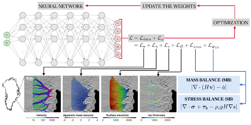
Uncovering new bed features, with uncertainties, in the interior of the Greenland Ice Sheet
Key Personnel Mansa Krishna, Cheng Gong, Mathieu Morlighem
Research Objective
The objective of the study is to use physics informed machine learning to infer the bed topography for the entire Greenland Ice Sheet.
- Cheng, G., Krishna, M., and Morlighem, M.: A Python library for solving ice sheet modeling problems using Physics Informed Neural Networks, PINNICLE v1.0, EGUsphere [preprint], https://doi.org/10.5194/egusphere-2025-1188, 2025
- Krishna, M., Cheng, G., and Morlighem, M.: Inferring subglacial topography using physics-informed machine learning constrained by two conservation laws, in prep.
Subglacial topography, or the bed topography, beneath the Greenland Ice Sheet is a fundamental control on ice dynamics and its response to climate change. Yet, it remains difficult to measure and existing descriptions of the bed topography rely on few observations. Poor constraints on the bed topography are a key cause for uncertainty in model projections. While the use of mass conservation and the development of BedMachine Greenland substantially improved the representation of the bed topography, this approach is limited to fast-flowing sectors and in regions with complex topography. This research presents an alternative to traditional numerical methods, using Physics-Informed Neural Networks (PINNs) to better constrain the bed topography. We describe a novel approach using two conservation laws that are coupled within a PINN framework and apply this approach to several regions in the Greenland Ice Sheet, including the slow-moving interior. The PINN is trained with both the conservation of mass and an approximation of conservation of momentum (i.e., the Shallow-Shelf Approximation), allowing us to simultaneously infer the ice thickness and basal shear stress using observable ice sheet features in a mixed inversion problem. The aim of this research is to generate map for the entire Greenland Ice Sheet, while also generating a map of the uncertainty, thus improving on current representations of the bed topography for ice sheet modeling and cryosphere applications.
Causal Modeling of Supraglacial Lake Evolution under Spatial Distribution Shift
Key Personnel Emam Hossain, Dr. Devon Dunmire, Dr. Md Osman Gani, Dr. Aneesh Subramanian
Research Objective
The objective of the study is to model supraglacial lake evolution by integrating causally identified predictors from multi-source satellite and climate time series to enable interpretable and robust classification of lake outcomes across diverse spatial regions and climate conditions in Greenland.
- Hossain, E., Ferdous, M. H., Dunmire, D., Subramanian, A., & Gani, M. O. (2025). Causal time series modeling of supraglacial lake evolution in Greenland under distribution shift. Under review at SIGSPATIAL ’25.
- Ferdous, M. H., Hossain, E., & Gani, M. O. (2025). TimeGraph: Synthetic benchmark datasets for robust time-series causal discovery. In Proceedings of the 31st ACM SIGKDD Conference on Knowledge Discovery and Data Mining (KDD ’25).
- Hossain, E., Gani, M. O., Dunmire, D., & Subramanian, A. C. (2025). RPS-TSC: Time series classification of supraglacial lakes via reconstructed phase space modeling. Under review in Deep Learning Applications, Taylor & Francis.
- Dunmire, D., Subramanian, A. C., Hossain, E., Gani, M. O., Banwell, A. F., Younas, H., & Myers, B. (2025). Greenland ice sheet-wide supraglacial lake evolution and dynamics: Insights from the 2018 and 2019 melt seasons. Earth and Space Science, 12(2).
- Hossain, E., Gani, M. O., Dunmire, D., Subramanian, A. C., & Younas, H. (2024). Time series classification of supraglacial lakes evolution over Greenland Ice Sheet, ICMLA 2024.
Causal modeling provides a principled foundation for uncovering stable, invariant relationships in time-series data, offering enhanced robustness and generalization under distribution shifts. However, its potential remains underexplored in spatiotemporal Earth observation settings, where traditional machine learning models often rely on purely correlational features that fail to transfer across heterogeneous domains. In this work, we introduce a regionally-informed causal time-series framework that integrates lag-aware causal discovery with sequence classification to improve out-of-distribution (OOD) performance and scientific interpretability. Leveraging multi-modal satellite and climate reanalysis data — including Sentinel-1 microwave imagery, Sentinel-2 and Landsat-8 optical imagery, and CARRA meteorological fields—we identify stable, domain-specific predictors of supraglacial lake evolution over Greenland using the Joint PCMCI+ (J-PCMCI+) algorithm. Causal graphs are estimated globally and within each geographic region, and the resulting causal parents, along with their timelags, are used as input to lightweight classifiers. Evaluation on a balanced benchmark of 1000 manually labeled lakes from two climatologically distinct melt seasons (2018–2019) shows that causal models consistently outperform correlation-based baselines, yielding up to 12.6 % improvement in OOD accuracy. Our findings demonstrate the effectiveness of causal discovery in constructing interpretable, generalizable models for dynamic Earth surface processes under spatial and climatic variability.
DeepNet for Ice Calving Analysis
Key Personnel Rohan Putatunda, Sanjay Purushotham, Ratnaksha Lele, Vandana P. Janeja
Data & Model
Research Objective
The objective of the study is to develop an integrated deep learning and physics-informed framework that segments glacier calving fronts, forecasts their future positions, and predicts the drift trajectories of resulting icebergs. This enables accurate, scalable monitoring of ice mass loss and its maritime impacts
- Rohan Putatunda, Sanjay Purushotham, and Vandana P. Janeja. 2024. SEATTNET: UNET Enhanced with Squeeze-Excited Attention Gates for Ice-Calving Front Segmentation. In 2024 International Conference on Machine Learning and Applications (ICMLA). IEEE. Miami, Florida
Ice calving, the process where large ice masses detach from a glacier’s terminus, is a significant driver of ice mass loss and contributes to global sea-level rise. In ice calving, ice calving fronts refer to the terminus regions where these events occur, often producing icebergs as large as Manhattan, which eventually fragment into smaller pieces, or “chicklets.” These chicklets, influenced by environmental forces such as ocean currents and winds, follow complex trajectories that can disrupt maritime routes. Although traditional methods for monitoring ice-calving fronts rely heavily on manual reviews of time series satellite imagery, they are time-intensive, prone to human error, and lack scalability. Recent advances in deep learning have introduced automation in segmenting ice-calving fronts, but critical challenges such as predicting future calving front positions and forecasting chicklet trajectories remain underexplored. This thesis addresses three fundamental challenges in understanding and predicting ice-calving processes. First, it tackles the challenge of accurate segmentation of ice calving fronts, characterized by sparse pixel representation, through SEATTNET, a novel hybrid attention model that combines squeeze-and-excitation (SE) blocks with spatial attention gates to enhance feature representation and segmentation accuracy. Second, it explores forecasting future ice-calving front position, where the absence of explicit spatiotemporal data and the nonlinear nature of latitude-longitude temporal sequences present significant challenges. To address these, a georeferenced dataset derived from segmentation masks is utilized alongside the GlaSpectra model, which employs spectral convolution layers along with FFT and IFFT to capture global and local spatial relationships, enabling precise trajectory forecasting. Finally, this thesis also proposes to tackle the challenge of predicting the movement of calved ice fragments, known as icebergs or “chicklets,” whose trajectories are highly unpredictable due to the influence of ocean currents, winds, and other environmental factors. To address this, we used spatiotemporal data of iceberg movement over time and applied ConvLSTM layers to capture both the spatial patterns and temporal dynamics. To make predictions more accurate, we developed a custom drift loss function that focuses on two key aspects: how the size and shape of the chicklets change over time and how their movement patterns evolve. The loss function incorporates the principle that the larger the volume of the ice mass, the slower its movement pattern is likely to be, ensuring that the model captures this critical physical relationship. This approach enables our proposed deep learning based model to not only predict the trajectory of the icebergs but also understand the relationship between their motion and their changing dimensions. By addressing these complexities, this research not only advances the use of AI in glaciology, offering practical, and scalable, tools for studying and predicting ice calving and its after-effect of ice chicklets behavior, but also has potential applications in studying landslide movements, and coastal erosion movement.
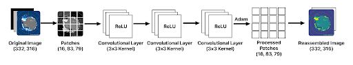
Predicting Sea Ice Concentration over Antarctic region using Deep learning Models
Key Personnel Sai Vikas Amaraneni, Sudip Chakraborty, Vandana P. Janeja
Prediction
Research Objective
The objective of the study is to improve sea ice concentration prediction by developing Patch-CNN using satellite images and ConvLSTM using climate variables – both optimized on HPC systems.
- Amaraneni, S. V. (2025, April). Predicting Antarctic Sea Ice Concentration using ConvLSTM. Poster presented at COEIT Research Day, University of Maryland, Baltimore County (UMBC). Recipient of the Doctoral Research Poster Award.
- Amaraneni, S. V., Devnath, M. K., Chakraborty, S., & Janeja, V. (2024, December). Forecasting sea ice extent with a Patch-CNN model: Daily to two-week predictions. Presented at the AGU Fall Meeting, Washington, DC. (Session C14A-06).
Antarctic sea ice is crucial in regulating global climate by influencing ocean salinity, circulation, and sea level rise. Antarctic sea ice acts as a protective buffer for the ice shelves from thermal advection and mechanical forces that trigger the disintegration of ice shelves leading to sea level rise. However, current ongoing sea ice retreat events can cause excessive ocean warming. They will lead to changes in ocean circulation, which influences local and regional climate along with marine wildlife thereby affecting sea level rise. Antarctic sea ice can raise sea level by 200 ft if completely melted. Unlike the Arctic, which has shown a continuous decline since 1978, Antarctic Sea Ice Extent (SIE) grew until 2015, reaching a record 20.14 million km² in 2014, before experiencing a sharp decline in 2023 by reaching a record low extent of 1.965 million km². This variability has led to a limited understanding of Antarctic sea ice dynamics compared to the Arctic. To address this, we developed a Patch Convolutional Neural Network (Patch-CNN), which segments daily SIE images into 16 patches to capture localized features. Our prior study demonstrated Patch-CNN’s superiority over traditional CNNs, achieving improved predictive performance. However, its accuracy declines with increasing lead time, as it relies solely on image data without incorporating critical climate variables such as Sea Surface Temperature (SST), wind, albedo, etc. To enhance prediction accuracy, we propose using Convolutional Long Short-Term Memory (ConvLSTM) to integrate spatial and temporal dependencies for SIE forecasting up to 3 months. By leveraging satellite data from CERES, MODIS, and other sources, our study aims to improve Sea Ice Concentration predictions (0: no ice, 1: full coverage), providing deeper insights into long-term climate patterns and sea ice retreat factors, ultimately contributing to better climate forecasting.
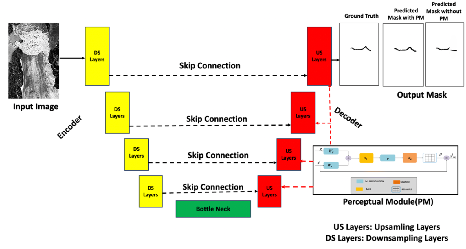
Ice Layer Annotation & Validation
Key Personnel Muhammad Behroze Hassan, Bayu Adhi Tama, Sanjay Purushotham, Nick Holschuh, Vandana Janeja
Research Objective
The objective of the study is to propose a new method for generating ice layer annotation (MorphoLayerTrace-MLT), and to develop a scalable, objective, and ground-truth independent framework for validating and automating ice layer annotations
- Tama, Bayu Adhi, Vandana Janeja, and Sanjay Purushotham. “Assessing Annotation Accuracy in Ice Sheets Using Quantitative Metrics.” IGARSS 2024.
- Tama, Bayu Adhi, Sanjay Purushotham, and Vandana Janeja. “A Pilot Study on the Challenges in Ice Layer Annotations” 13th International Conference on Climate Informatics, 2024.
- Tama, Bayu Adhi, Sanjay Purushotham, and Vandana Janeja. “MorphoLayerTrace (MLT): A Modified Automated Radio-Echo Sounding Englacial Layer-tracing Algorithm for Englacial Layer Annotation in Ice Penetrating Radar Data.” Proceedings of the 40th ACM/SIGAPP Symposium on Applied Computing. 2025.
Causal Discovery and Inference
Key Personnel Omar Faruque, Ziqi Yin, Dr. Sahara Ali, Dr. Yiyi Huang, Dr. Aneesh Subramanian, Dr. Nicole-Jeanne Schlegel, Dr. Md Osman Gani, Dr. Jianwu Wang
Data & Model
Research Objective
The objective of the study is to better understand the connections among components (sea ice, ice sheet, atmosphere, ocean, etc.) in the Arctic climate system
- Omar Faruque, Sahara Ali, Xue Zheng, Jianwu Wang. “TS-CausalNN: Learning Temporal Causal Relations from Non-linear Non-stationary Time Series Data.” [arXiv:2404.01466], 2024
- Sahara Ali, Uzma Hasan, Xingyan Li, Omar Faruque, Akila Sampath, Yiyi Huang, Md Osman Gani, Jianwu Wang. “Causality for Earth Science – A Review on Time-series and Spatiotemporal Causality Methods.” [arXiv:2404.05746], 2024
- Sahara Ali, Omar Faruque, Jianwu Wang. “Estimating Direct and Indirect Causal Effects of Spatiotemporal Interventions in Presence of Spatial Interference.” ECML-PKDD, 2024.
- Sahara Ali, Omar Faruque, Yiyi Huang, Md Osman Gani, Aneesh Subramanian, Nicole-Jeanne Schlegel, Jianwu Wang. “Quantifying Causes of Arctic Amplification via Deep Learning based Time-series Causal Inference.” ICMLA, 2023.
The growing availability and importance of time series data across various domains, including environmental science, epidemiology and economics, has led to an increasing need for time-series causal discovery methods that can identify intricate relationships in non-stationary, nonlinear and often noisy real world data. Existing constraint-based causal discovery methods for non-stationary time series data rely on conditional independence tests whereas score-based methods use statistical processes. In this work, we propose a Transformer Integrated Temporal Causal Discovery (TTCD) Framework to discover contemporaneous and lagged causal relations from non-stationary time series data. The proposed framework comprises a transformer-integrated Non-Stationary Feature Learner module to learn non-stationary features from input temporal data and a Causal Structure Learner module to discover causal connections between different variables utilizing the learned latent features from the Non-Stationary Feature Learner. Through experiments on multiple synthetic, real world and benchmark datasets, we demonstrate the empirical proficiency of our proposed approach as compared to several state-of-the-art methods. The inferred graphs for the real world datasets are also in good agreement with domain understanding.
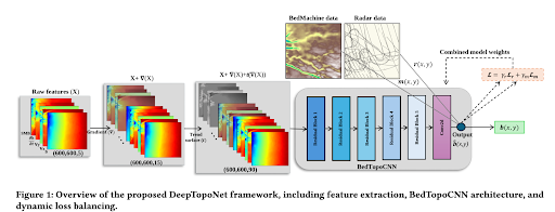
Frameworks for Subglacial Topography Estimation on the Greenland Ice Sheet
Key Personnel Mostafa Cham, Dr. Bayu Adhi Tama, Mansa Krishna, Homayra Alam, Omar Faruque, Gong Cheng, Dr. Jianwu Wang, Dr. Mathieu Morlighem, and Dr. Vandana Janeja
Research Objective
The objective of the study is to develop two deep learning frameworks, DeepTopoNet and GraphTopoNet, that effectively estimate Greenland’s subglacial topography by integrating radar-derived ice thickness data from BedMachine data, to address challenges posed by sparse, uncertain, and complex radar data.
- Tama, B. A., Krishna, M., Alam, H., Cham, M., Faruque, O., Cheng, G., Wang, J., Morlighem, M., & Janeja, V. (2025). “DeepTopoNet: A framework for subglacial topography estimation on the Greenland ice sheets.” arXiv. https://doi.org/10.48550/arXiv.2505.23980 (Submitted to SIGSPATIAL 2025)
- Tama, B. A., Alam, H., Cham, M., Faruque, O., Wang, J., & Janeja, V. (2025). “GraphTopoNet: Confidence-Weighted and Uncertainty-Aware Graph Learning for Sparse Spatial Prediction.” (Submitted to ICDM 2025)
XR Visualization and Interpretation of Radar Imagery
A team of collaborators at UMBC, Dr. Don Engel, Dr. Rebecca Williams, and Naomi Tack (research assistant), worked to develop WebXR visualizations of radar imagery for use by the expert radioglaciology community. This research has generated two publications focused on the WebXR product, and the team developed a user study to evaluate the utility of XR in interpreting radar imagery. Naomi Tack successfully defended her master’s thesis in April 2024.
Please click here to navigate to learn more and view the XR Visualization and Interpretation of Radar Imagery
Data & Model